
Skip to product information


**Please note: Actual layout may vary based on size. If you'd like to see a proof of the layout prior to production, let us know,


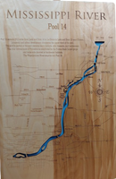
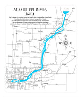
This is a beautiful, detailed, laser engraved and precision cut map, including lake information such as surface area, elevation and maximum depth.
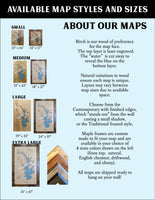
Included With All Maps:
- Points of interest laser engraved into the map face
- A blue, self-adhesive Swarovski crystal to mark your preferred location on the map
Our maps are made from beautiful birch plywood. Natural variances in the wood grain ensure a unique work of art. Once the map is cut, it is hand sanded multiple times, mounted on a blue board to highlight the water, and given a clear coat for a lustrous wood shine. Proudly made in the USA by American workers in an American owned business.
**Please note: Actual layout may vary based on size. If you'd like to see a proof of the layout prior to production, let us know,
Custom Engraving Available
Add up to 2 lines of custom engraving at no additional cost!
Standard Engraving:
Pool 14 extends 29.2 miles from Lock and Dam 14 in Le Claire to Lock and Dam 13 near Clinton. Industrial and urban development dominates the upper third of the pool. The middle portion of the pool contains many islands, side channels, and backwaters. The river downstream of Princeton is constricted by the Fulton-Rock Island gorge and lacks side channel or backwater habitats. The Wapsipinicon River empties into Pool 14.