
Skip to product information


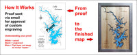
**Please note: Actual layout may vary based on size. If you'd like to see a proof of the layout prior to production, let us know,
The Ashuelot River is both a cold and warm water fishery that provides habitat for approximately 15 resident species, including eastern brook trout, large and small mouth bass, and walleye.
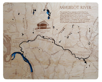
The Ashuelot River has six covered bridges. All six bridges are listed on the National Register of Historic Places. Four are in Swanzey: Carleton, Sawyers Crossing, West Swanzey, and Slate. The Cooms Covered Bridge and the Ashuelot Covered Bridge are in Winchester.


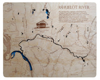
This is a beautiful, detailed, laser engraved and precision cut map, including lake information such as surface area, elevation and maximum depth.
Included With All Maps:
- Points of interest laser engraved into the map face
- A blue, self-adhesive Swarovski crystal to mark your preferred location on the map
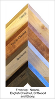
Our maps are made from beautiful birch plywood. Natural variances in the wood grain ensure a unique work of art. Once the map is cut, it is hand sanded multiple times, mounted on a blue board to highlight the water, and given a clear coat for a lustrous wood shine. Proudly made in the USA by American workers in an American owned business.
**Please note: Actual layout may vary based on size. If you'd like to see a proof of the layout prior to production, let us know,
Custom Engraving Available
Add up to 2 lines of custom engraving at no additional cost!
Standard Engraving:
The Ashuelot River originates at Butterfield Pond in Pillsbury State Park in Washington, New Hampshire and flows 64 miles before joining the Connecticut River in Hinsdale, New Hampshire.The Ashuelot River is both a cold and warm water fishery that provides habitat for approximately 15 resident species, including eastern brook trout, large and small mouth bass, and walleye.
The Ashuelot River has six covered bridges. All six bridges are listed on the National Register of Historic Places. Four are in Swanzey: Carleton, Sawyers Crossing, West Swanzey, and Slate. The Cooms Covered Bridge and the Ashuelot Covered Bridge are in Winchester.